

The type of chart on which meridians of longitude and parallels of latitude are at 90° to each other is called…
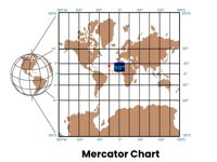
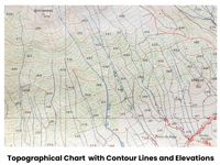
Refer to figures.
Note: The term “Theomorphic” is likely an old or obsolete term. Based on multiple sources, it does not refer to a map projection. It is possible that the examiner included this option to confuse students. Please let us know if you have more information regarding this question. Thank you!
Meridians
Meridians are imaginary vertical lines (lines of longitude) running north-south on Earth’s surface, connecting the North and South Poles.
Parallels of latitudes
Parallels of latitude are imaginary east-west lines circling the Earth that run parallel to the Equator, measuring distance north or south from the poles.
TYPES OF CHARTS
Conformal Chart (Figure 1)
A chart that preserves the relative proportions and angles of small areas. In a conformal projection, graticule lines (meridians and parallels of latitude) intersect at 90-degree angles, and at any point on the chart the scale is the same in all directions.
Topographical Chart (Figure 2)
A topographic chart (commonly referred to as a topographic map) is a detailed and accurate 2D representation of natural and man-made features on the Earth's surface.
Your Notes (not visible to others)
This question has appeared on the real examination, you can find the related countries below.


 Use Keyboard Shortcuts
